
Monday, May 30, 2011
Monday, May 16, 2011

On Guard! (1956)
IBM Military Products Unit presents a film about military computers.
'Protection comes high. Sky high. Today we must be on guard in the sky when it comes to protecting our resources; the national resources that are so precious to us. The offensive weapons of tomorrow are here today. Supersonic. Superdestructive. Seemingly unresistable. To protect the future of America the defence techniques of tomorrow had to be discovered now. They were discovered in electronics.'
SAGE Computer System (developed in the 1950's, operational by 1963)
Wednesday, May 11, 2011

Tuesday, May 10, 2011
Cyprien Gaillard, Pruitt-Igoe Falls (2008)
Not the demolition of the St Louis, Missouri housing complex, but a Glasgow tower block in 2008.
From the press release:
As the building collapses, the concomitant dust cloud spreads to cover where the structure once stood and conceals the light emanating from off-camera. This leaves the scene in near blackness before a glow languidly re-illuminates the screen. Only, as the video continues, the emphemeral nebula containing the airborne remnants of the building transform into the monumental downrush of
MIT List Visual Arts Center
Monday, May 02, 2011
It's All Out There
One of the more compelling aspects of John Hillcoat’s 2009 adaptation of Cormac McCarthy’s novel The Road is the fact that the film’s post-apocalyptic landscapes are not computer generated but largely shot on real locations in the United States. Abandoned freeways and strip mines in Pennsylvania, wrecked shopping malls in New Orleans, and clouds borrowed from 9/11 footage provide the sources for a space of only too-believable devastation. In an era when the indexical function of photography has largely been overruled by CGI, the decision to shoot the film in real places creates a kind of reverse-uncanny: that which is supposed to be fake is in fact actually there. Hillcoat’s aim is in part to remind viewers of what they have already seen rather than create an alienating and unfamiliar nightmare. As he explains, ‘the scenes -- the forgotten 18-wheeler jackknifed on a freeway bridge, the gas stations littered with useless contraptions, the sinister farmhouses, the sheds with their hand tools piled like ancient contrivances -- all of it calls up the now.’ This world is ‘sickeningly familiar’ (Chiarella 2009: 91).
It may be true that urban blight and environmental catastrophe are proximate enough that it is not necessary to make them up, but it is also fair to say that the majority of The Road’s audience knows of devastation and dereliction largely through their mediation in photography and film. Extreme poverty and despoliation are both close at hand and far away, present largely as images of realities held at bay by structural inequality and diligent policing. From the tinted window of the SUV it may be possible to glimpse social collapse between home and the mall, but this reality is assuredly kept at safe distance, for the time being, by the place-holding technologies of the property-owning classes. In many ways, the fears The Road plays upon are less the terrors of nuclear or environmental cataclysm and more related to the more prosaic horror of homelessness and destitution. Being left literally on the road and in the neighborhood rather than cruising through it is what is really frightening.
Reference
***
“For all the spectacle of CGI,” he [Hillcoat] said, “there’s something alien and unreal about that domain, like a videogame. It’s enjoyable for that fantasy aspect, but the book felt so much more real.”

It may be true that urban blight and environmental catastrophe are proximate enough that it is not necessary to make them up, but it is also fair to say that the majority of The Road’s audience knows of devastation and dereliction largely through their mediation in photography and film. Extreme poverty and despoliation are both close at hand and far away, present largely as images of realities held at bay by structural inequality and diligent policing. From the tinted window of the SUV it may be possible to glimpse social collapse between home and the mall, but this reality is assuredly kept at safe distance, for the time being, by the place-holding technologies of the property-owning classes. In many ways, the fears The Road plays upon are less the terrors of nuclear or environmental cataclysm and more related to the more prosaic horror of homelessness and destitution. Being left literally on the road and in the neighborhood rather than cruising through it is what is really frightening.
Reference
Chiarella, Tom (2009) ‘The Most Important Movie of the Year’ Esquire June: 87-91.
***
The following stills, captions, and quotations are taken from Hugh Hart, 'The Road Takes Desolate Journey From Page to Screen,' Wired, November 24, 2009.
Hillcoat and his team spent several months in preproduction matching scenes from the book to locations in states including Pennsylvania, Oregon and Louisiana.
“We referenced all these man-made and natural disasters, then went all around looking for that stuff — it’s all out there,” Hillcoat said.
Production designer Chris Kennedy scouted a number of locations in post-Katrina New Orleans, including the devastated neighborhood pictured above. He also found Pennsylvania to be a treasure trove of desolate settings. “The state has depressed socioeconomic situations in suburbs like Braddock and Keysport and devastated mining areas with coal piles and fly-ash piles that looked like a blackened landscape,” Kennedy said in a statement.
 |
Production designer Chris Kennedy scouted a number of locations in
post-Katrina New Orleans, including the devastated neighborhood pictured above. He also found Pennsylvania to be a treasure trove of desolate settings. “The state has depressed socioeconomic situations in suburbs like Braddock and Keysport and devastated mining areas with coal piles and fly-ash piles that looked like a blackened landscape,” Kennedy said in a statement. |
 |
An 8-mile stretch of abandoned Pennsylvania freeway outside Pittsburgh
served as the setting for several sequences. Throughout the 60-day shoot, cinematographer Javier Aguirresarobe worked hard to render a pollution-infested landscape. |
 |
This maritime wreckage was filmed in Louisiana by an Imax documentary
crew two days after Hurricane Katrina devastated New Orleans and the surrounding area. “Cormac’s material felt so familiar, like we’ve already seen it,” Hillcoat said. “That’s why we went to the leftovers of Katrina. Then we used CGI to take out the bright blue sky and green grass.” |


Collapsed Overpass
 |
San Fernando, California, Earthquake February 1971.
Collapsed overpass connecting Foothill Boulevard and the Golden State Freeway. Feb 10, 1971.
Photo by R.E. Wallace, USGS.
|
 |
San Fernando, California, Earthquake February 1971.
Collapsed highway overpass, INTERSTATE 5 and 14. Februrary 1971.
|
 |
The Doobie Brothers, The Captain and Me
|
 |
The Nitty Gritty Dirt Band, Stars and Stripes Forever
Interesting post here at Deadwrite's Dailies. |
Tuesday, April 12, 2011
John McCracken 1934-2011
 |
Untitled slab painting, resin and fiberglass
sculpture 1981. Smithsonian American Art Museum
|
“Even before I did concerted studies of U.F.O.s it helped me maintain my focus to think I was trying to do the kind of work that could have been brought here by a U.F.O.”
NY Times Obituary
Friday, April 08, 2011
Thursday, April 07, 2011


Tuesday, April 05, 2011
Julie Mehretu
 |
Julie Mehretu, "Atlantic Wall", 2008-09. Ink and acrylic on canvas, 304.8 x 426.7 cm.
Commissioned by Deutsche Bank AG in consultation with the Solomon R. Guggenheim
Foundation for Deutsche Guggenheim
|


John Martin
 |
The Destruction Of Sodom & Gomorrah (1852)
|
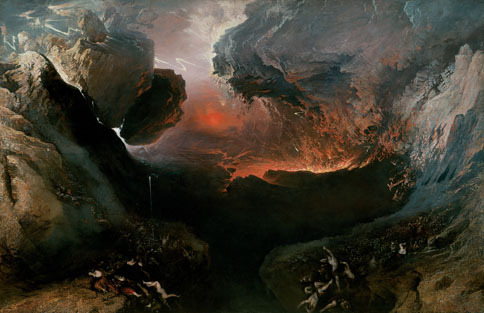 |
The Great Day of His Wrath (1851-1853)
|


Tuesday, March 29, 2011
Teddy Cruz
Thanks to Adam Sharr for putting me on to Teddy Cruz.
See also:
- Estudio Teddy Cruz
- Teddy Cruz – What adaptive architecture can learn from Shantytowns, Resilience Science 2006
Monday, March 21, 2011

Monday, February 21, 2011
The Unofficial Countryside


Not only was it a suprise to see a feature on Nick Papadimitriou on Newsnight last Thursday, there was the unexpected pleasure of seeing a short clip from Richard Mabey's 1975 TV programme The Unofficial Landscape.
Monday, January 17, 2011
The Sea in their Blood (1983)
I'm no fan of Peter Greenaway but this COI-commissioned documentary about Britain’s coastline is great.
Friday, January 07, 2011
William Bunge, Nuclear War Atlas (1982)
Bill Bunge's 1982 Nuclear War Atlas poster. From Martin Dodge's Cyber Badger Research Blog.
See D. Wood and J. Krygier, 'Maps and Protest,' in Rob Kitchin and Nigel Thrift, eds., International Encyclopedia of Human Geography (Amsterdam: Elsevier, 2009), pp. 438-9:
'[The map] folded, William Bunge, its principal author recalls, "into a 5 in x 8 in. size designed for peace demonstrations where it was abundantly sold." Black, white, and red, the very design and layout of the maps were inflammatory, but the reframing of data that had been culled from a variety of impeccably researched sources (e.g., Progress in Nuclear Energy, Health Physics, Child Psychology) was largely carried out by the titling: "The march of doom", "Patriotic poisoning", "The sea of cancer". "The sea of cancer" was a map of the U.S. largely covered with red stippling that indicated areas that would be exposed to 100 or more rem of radiation in a full nuclear war. "Not only will most of the United States be washed in immediate radiation," read the caption, "but even the white areas on the map are safe only in the sense that people in the open escape short term damage but not long term. The cancer is everywhere." A map of the world makes the point that the boundaries of a missile armed United States and Soviet Union are global: "To state the new geographic reality using the militaristic language of the 1980s, ‘The Russians are not coming. They are already here.’ At least they are straight up in the sky above us and thus are bounded by the earth’s surface, not ‘contained’ by boundary lines. They can kill anything on the earth’s surface and for a considerable depth below it; the Americans likewise. 'Containment' has been a mathematically proven bankruptcy for almost twenty years." By dramatically reframing simple truisms like these, The Nuclear War Atlas gave people whole new grounds for protesting nuclear weapons.'
Science Fiction in the Present 26 May 2011

26th May 2011 - Research Beehive, Newcastle University. A one day symposium organised by the School of Architecture, Planning and Landscape featuring the following speakers:
- Noel Sharkey (University of Sheffield)
- Stephen Graham (Newcastle University)
- Mark Dorrian (Newcastle University)
- David Cunningham (University of Westminster)
- Matt Carr (Independent Scholar)
- John Beck (Newcastle University)
- Iain Boal (Birkbeck/Retort)
Trevor Paglen: Blank Spots
Some snippets from Dirty Wars:
Planning the rescue of a kidnapped friend who has been squirreled away in a disused government installation, two men in Thomas Pynchon’s Vineland (1990) study maps of the area: “They peered at the maps, each with that enigmatic blank in the middle, like the outline of a state in a geography test, belonging to something called ‘the U.S.,’ but not the one they knew” (250).
The unmarked space on the map has become a common trope in writing about the American West in recent years, a double motif that speaks on the one hand of the shroud of secrecy covering military-industrial activity and on the other the resistant spaces beyond the inventory of the U.S. standing-reserve.
In Terry Tempest Williams’ Refuge
The blank space on the map is a visible marker of the state of exception that, as Giorgio Agamben explains in
The House in the Middle (1954)
'In the house on the right all the earmarks of untidy housekeeping...'
Producer: National Paint, Varnish and Lacquer Association
Sponsor: National Clean Up-Paint Up-Fix Up Bureau. Produced with the cooperation of the Federal Civil Defense Administration.
Producer: National Paint, Varnish and Lacquer Association
Sponsor: National Clean Up-Paint Up-Fix Up Bureau. Produced with the cooperation of the Federal Civil Defense Administration.
Thursday, January 06, 2011
Lost Landscapes of Detroit (2010)
Compilation of historical images of Detroit, Michigan (1917-1970), edited by Rick Prelinger for presentation at Museum of Contemporary Art Detroit (MOCAD) on February 10, 2010.
This movie is part of the collection: Prelinger Archives
Heavy Water: A Film for Chernobyl (2009)
The rest of this is available on Youtube. Or the DVD is available: Heavy Water: a film for Chernobyl
Subscribe to:
Posts (Atom)